
The atmosphere is contained within a space defined by earth’s gravitational field and the earth’s surface. The force field we experience as gravity isn’t perfect in a number of ways. The atmosphere is packed near the earth’s surface by the atmosphere above it resulting in a pressure / density gradient from 14.7 PSI to nearly 0 PSI.
Weather is quite visible. We are all familiar with the altitude that water condenses. I call it cloud level. Gaseous water or humidity in the atmosphere makes the atmosphere less dense, which is another way to say more buoyant. I know this is counter intuitive since water is rather heavy and because many authors have referred humid days as having ‘heavy’ air. Remember humid air is light air. Buoyant air rises as because it is replaced (think floated) by heavier dryer and/or cooler less buoyant air.
Air cools adiabatically as it rises because air pressure decreases. This is much like the action of Freon in an air conditioner or refrigerator. A motor and mechanical compressor compresses the gas refrigerant heating it up, cools the high-pressure gas and lets it expand. The resulting cold gas removes heat from refrigerators, freezers, automobiles and homes. Water’s role in the atmosphere is very similar to Freon in mechanical air conditioners.
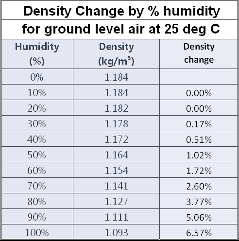
The two most significant reasons ground level air becomes more buoyant are temperature and humidity. The humidity change is huge. There can be a buoyancy change of more than 6% at ground level due to humidity alone.
Even when the atmosphere is below freezing and the total water content is very low, there can be significant changes in total buoyancy with humidity changes.
The following chart of density by temperature can be misleading. Large swings in humidity are not all that uncommon but changes of more than 10 degrees C per hour are relatively uncommon. The adiabatic change (DALR) change in temperature is about 1 degree C per 1000 foot change in altitude close to ground level. In only slightly abnormal conditions such as tornado weather the density change in the first 100 foot from ground level can be ten times greater or more than the entire change in density due to adiabatic cooling. It is really true that it isn’t the heat that gets you, it’s the humidity.
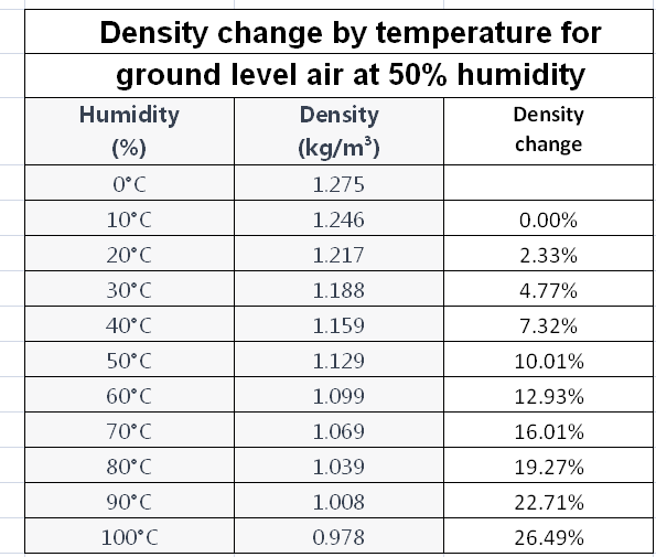
Large changes in atmospheric temperature at ground level are rare. For example, when a cold front containing tornadoes passes during summer the atmospheric temperature might change 10 degrees C say from 40 degrees C to 30 degrees C. This is a density change of 2.6%. Ground level humidity might change by 90% while rising from ground level to cloud level resulting in a 5% density change. The combination of temperature and humidity is the driving engine for tornadoes.
As air with gaseous water (humidity) rises it cools. The water tends to condense due to the loss of temperature and pressure. Ground level air, which has risen and adiabatically cooled, reaches the point at which water condenses and becomes visible. Water releases heat as it condenses. Its heat transfers to other air molecules heating them and making them lighter. The weight to surface area of these water droplets is so small they float around in the atmosphere much like dust motes. Air warmed by water condensation rises independently leaving the condensed water molecules behind at or near cloud level. Air warmed by water which condensed into clouds continues to travel upward because it was heated by water condensation creating a vertical column of buoyant air. This concept is important because air movement without condensed water is nearly impossible to track vertically with a satellite.
If you plot the atmosphere’s temperature gradient with temperature on the x axis and altitude on the y axis the shape resembles the Greek letter Sigma (Σ). This graph is commonly available in weather literature. I’ve added a dark blue area near the x-axis half the planet’s atmosphere is in this area, which extends from ground level to about 5,300 meters or 18,000 feet or about 3 1/2 miles.
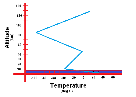
I contend that virtually all weather is nearly completely controlled within that bottom 50% (by weight) of the atmosphere.
There are two types of mesocyclone the global effect mesocyclone such as a hurricane and the local effect mesocyclone such as the tornado. The two common types of tornado are the isolated tornado associated with summer super cells and the cluster tornadoes associated with weather fronts.
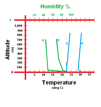
Isolated tornadoes might have a temperature and humidity profile as presented here. Ground temperature is relatively high with minimal temperature gradient or a low temperature change between ground level and cloud level before a tornado the lines marked B, and after a tornado, the lines marked A. Notice that the (A) for humidity (green) changes hugely especially in the first 100 meters. I can show that is true in the first 100 feet from the ground.
Humidity close to the ground is extremely high due to the effects of plant photosynthesis and respiration. High humidity air is the source of tornado energy. This is the reason nearly all inflow air is so very close to the ground. The same humidity profile can effect after light showers when a layer of high humidity air is close to the ground.
Humidity and temperature lower drastically after a tornado. High-humidity, high-temperature ground level air replaces by upper level cool, dry air. These are the A lines in the figure. The vertical weather section of this document explains this process in detail.
Another characteristic of isolated tornadoes is the so-called anvil cloud. I refer to it as the flat top cloud because that cloud is associated with the ice level in the atmosphere. Any humidity in the atmosphere quickly converts to ice pellets not snow. Ice is much denser and falls quickly, sometimes all the way to ground level. It is also invisible to the naked eye. Stratosphere level wind blowing visible condensate causes the tongue of the flat top cloud.
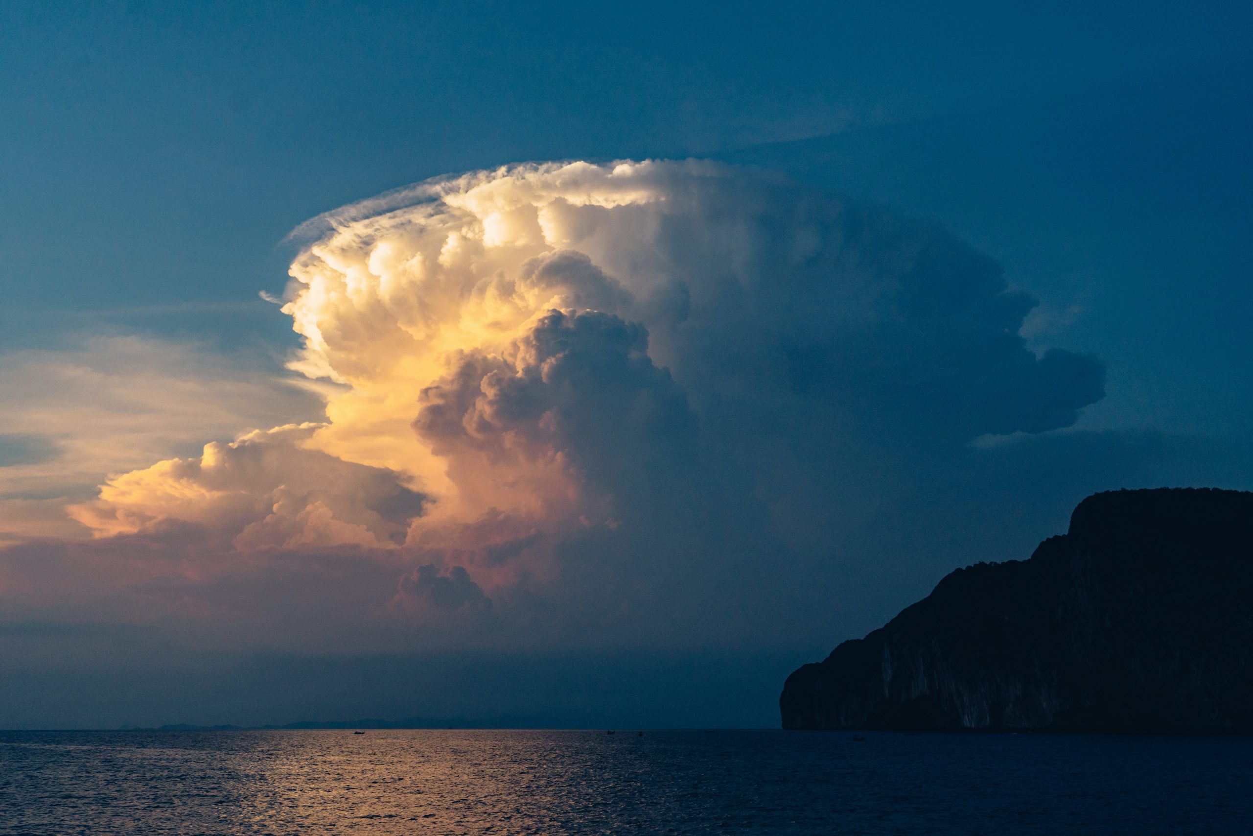
As you can see all the flat top clouds (stratosphere limited altitude) are not anvil shaped.
The top of a flat top cloud indicated the other critical thermal extreme for water phase changes, ice. The top of a flat top cloud indicates water’s freezing point. When rising air crosses ‘standard freezing level’ its water tends to freeze. This is generally about 15,000 feet or about 3 miles altitude. It is no coincidence that a flat top cloud indicates the possibility of hail. Nearly all atmospheric moisture becomes ice at this altitude.
This is also the top of the troposphere and bottom of the stratosphere. That does NOT mean that air doesn’t rise into the Stratosphere, it most certainly does. Not all moisture drops out of the atmosphere at the ice level. Not only that but humid air above the ice level has about the same buoyancy as humid air below the ice level. It is just invisible to the eye. Air temperature in the stratosphere increases with altitude. I posit this is because there is still moisture adding heat to air as it condenses and falls to the Troposphere where evaporates.
What I’m discussing is a very powerful engine powered by water from the earth’s surface stretching to the top of the stratosphere.
You may have noticed the down-sun side (the side away from the sun) of clouds is dark by comparison. This is because condensed water in the cloud has adsorbed solar energy. I calculate the amount later in the text but a single supercell can absorb solar energy equivalent to a multi-reactor nuclear power plant.
The adsorbed heat both evaporates the condensed up-sun condensed water and warms the air around it. This greatly increases the air’s buoyancy both at ground level and into the stratosphere. Now you see why I discussed water exchange mechanisms in the stratosphere. This creates a vertical chimney of high velocity air, which will accelerate air vertically all the way down to ground level by the same mechanism as a stove’s chimney.
Coriolis effects cause rotation, which has the same effect as the walls of a stove or fireplace chimney. Centripetal force pumps heavier, less buoyant air to the chimney wall and lighter more buoyant air to the interior of the chimney enhancing the buoyant effect in the center of the chimney perpetuating the mesocyclone’s flow.
This chimney extends to the ground from the sun generated power miles above. Without the high-humidity, high-buoyancy layer of air very close to the ground pins the vertical air flow all the way to ground level, taking lives and destroying property.
I define another critical altitude as cloud level. Cloud level is that altitude where the dew point is equal to ambient temperature. Atmospheric moisture becomes visible at cloud level. Fog occurs when cloud level is at ground level. Another, slightly more scientific definition of cloud level is that altitude where the dew point is at the same temperature as 100% humidity. When rising ground level air crosses cloud level, it tends to condense becoming visible.
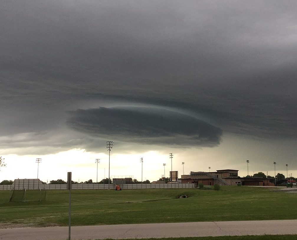
The spinning barrel cloud, which is currently called a wall cloud for some unimaginable reason is the proof of the above theory as well as another theorem. (Photo by Geo Lightspeed6) Tornado wall diameter has a positive relationship to differential vertical density. Put into practical terms the barrel cloud may be miles in diameter and rotating slowly. Low inflow velocity limited by low differential density at that level accounts for the large diameter of the spinning barrel cloud. When the spinning effect begins to take in air from below cloud level, the decrease in local pressure causes condensation causing the barrel’s body to become visible. The barrel is not moving down, reduced air pressure due to up flow velocity is causing condensation making the low-pressure area visible.
Then a much smaller diameter conical flow becomes visible in the center of the barrel cloud’s rotation. This is the tornado. You don’t necessarily see the entire tornado, you only see the area where differential pressure is low enough to cause condensation. This is the same condensation you sometimes see above airplane wings or under race car wings.
Each of water’s phase transitions from solid to liquid to gas and back again involves very significant transfers of energy. It requires removing 144 BTU per pound to freeze water and 970 BTU per pound to evaporate water. It requires 1 BTU to change a pound of water one degree Fahrenheit and 0.24 BTU to change one pound of dry atmosphere one degree Fahrenheit. It requires 186 BTU to heat one pound of water from 33 degrees F to 119 degrees F but 970 BTY to boil one pound of water.
Buoyancy is the tendency for heavier fluids to displace lighter fluids within a confined space subjected to a gravitational field or centripetal field such as earth’s gravity or the earth’s atmosphere. In either field, the lighter fluid is displaced away from the greater field strength.
Air at 0 degrees Fahrenheit and 10% humidity has a density of approximately 0.03121 kilograms per cubic meter or 0.001948 pounds per cubic foot. Air at 90 degrees Fahrenheit and 90% humidity is approximately 0.03266 kilograms per cubic meter or 0.002039 pounds per cubic foot. The ratio of cold-dry air density to warm-humid air density is approximately 4.6%. This small difference is directly responsible for tornadoes and hurricanes.
A hot air balloon demonstrates the vertical effects of atmospheric density. A balloon rising in the earth’s gravitational field is an example of gravitational buoyancy. A cold front descending from Polar Regions displacing warm equatorial air is an example of horizontal or tangential buoyancy.
Enough words, would you like some math?
Next Centripetal Field
Back to Abstract